Ordnance Survey Maps
This series offers reprints of the first edition of the one-inch Ordnance Survey maps of England and Wales, dating from 1805 to 1900. Detail includes villages, hamlets, farms, county boundaries, roads and railways.
Select Location
Select Condition
Select Location Type
From $7.50
Original: $24.99
-70%Ordnance Survey Maps—
$24.99
$7.50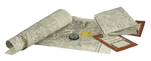
Description
This series offers reprints of the first edition of the one-inch Ordnance Survey maps of England and Wales, dating from 1805 to 1900. Detail includes villages, hamlets, farms, county boundaries, roads and railways.